
One of the main considerations for GIS teams deciding to adopt the AI Vectorizer is the amount of time it will save in real-world digitizing.
Vectorizing maps, the process of manually creating the vector representation of a raster map image, is tedious and time-consuming. It's frequently cited as a GIS analyst's least favorite task. With our AI QGIS plugin, you can digitize between 2 and 4 times faster than doing it by hand.
Digitizing Time Comparison
To help prospective customers project the time savings that adopting an AI Vectorizer into their GIS workflow, our CTO, Brendan Ashworth, spent two hours digitizing the same USGS quadrangle both by hand with the QGIS Add Line Feature tool, and by using the AI Vectorizer QGIS plugin.
Standard Map Region
I digitized MF-2349, a geological survey map produced by the USGS and the California Division of Mines and Geology. The map features overlapping polygons of varying size, shape, and color, providing a varied test for the plugin.
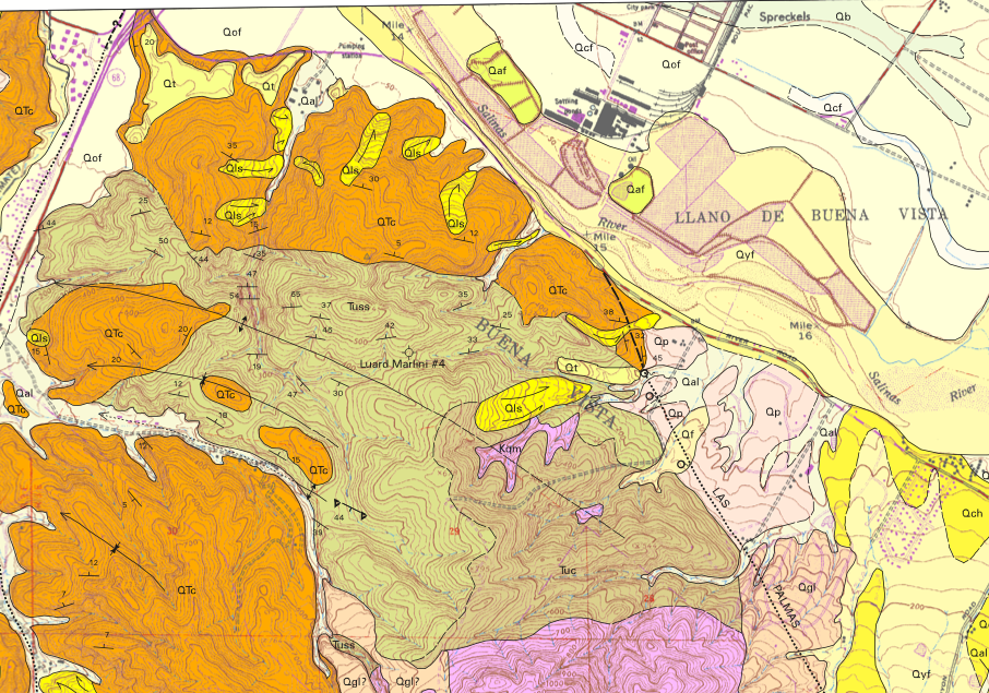
To save my sanity, I digitized approximately the pictured region above, which is the upper right hand corner of the map. I did the same polygons for both the hand and AI tests.
Digitization Results
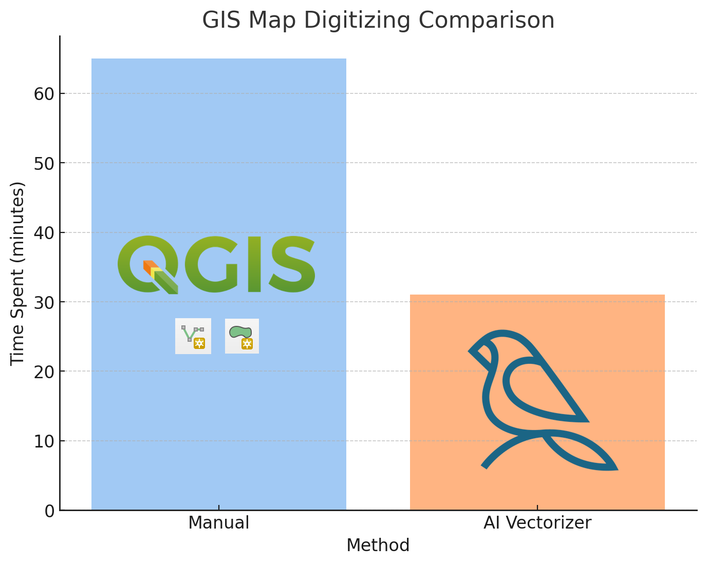
Digitizing the standard set of polygons took 65 minutes by hand, but just 31 minutes with the AI Vectorizer, meaning with AI I could digitize more than 2x faster.
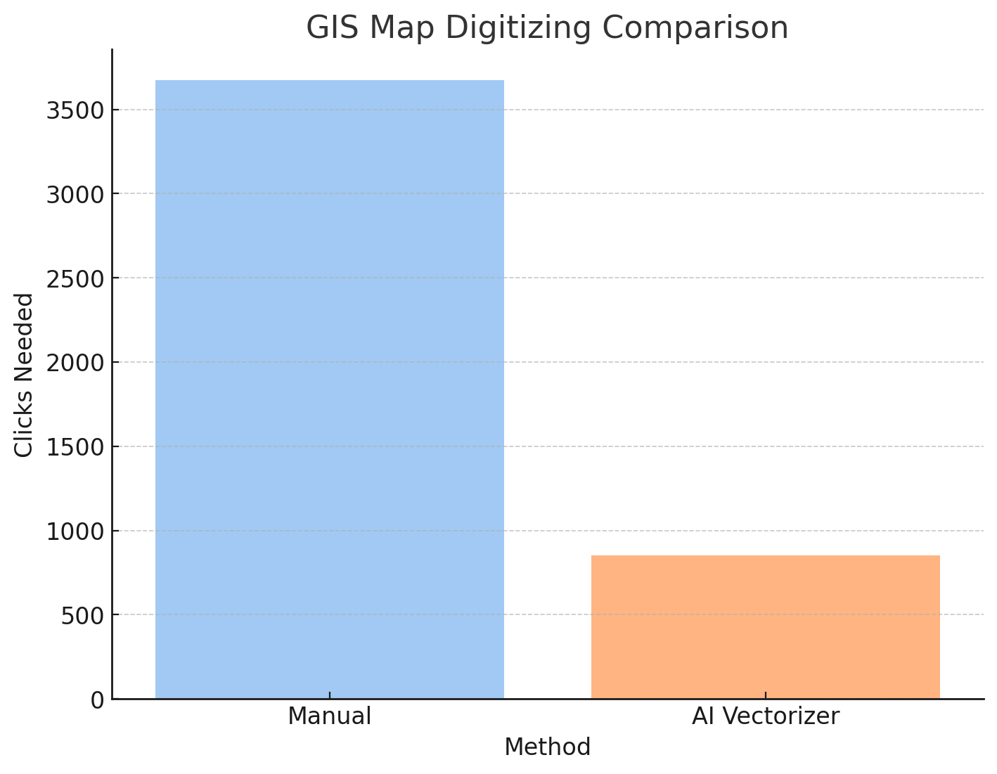
For both, I was trying my best to give the fastest digitization, and there's a couple of errors in both outputs. I managed to add 3,673 vertices by hand in 65 minutes, which is nearly one vertex per second!
The AI Vectorizer plugin also required much less interactions, needing only about 16% of the clicks as doing it by hand, which requires one click for every vertex.
My main frustration with the Add Line Feature tool was how much time I had to spend adding vertices to a curved line. On the other hand, the AI Vectorizer didn't save me much time when digitizing straighter lines, and I often used the shift key to add normal vertices without autocomplete. The nice thing about the plugin is I can switch back and forth between autocompleting, and if I'm not using the autocomplete then it's not actually slower than doing it by hand. (There's a longer plugin tutorial here).
You can watch the full recording of me digitizing this map on our YouTube video "Digitizing a USGS Geology Map in QGIS [1 hour uninterrupted]". The AI and by-hand versions are overlaid on top of eachother, so you can compare them as I digitize.
Raster and Vectors for Evaluation
Raster: "Geologic map and map database of the Spreckels 7.5-minute quadrangle, Monterey County, California"
- GeoTIFF is available on the USGS National Geologic Map Database
Vector Outputs:
- Digitized by hand (GeoPackage 188KiB)
- AI Digitized (GeoPackage 565KiB)
How does the AI Vectorizer compare to Segment Anything?
Segment Anything is Meta's foundation model for object segmentation that can identify and outline objects in images. While both tools assist with digitization, they excel in different use cases:
Segment Anything tends to outperform in polygon digitization of aerial imagery, where it can automatically detect and segment distinct objects like buildings, fields, or water bodies. It's particularly effective when you need to quickly identify and extract polygonal features from satellite or aerial photos.
Our AI Vectorizer gives high accuracy when digitizing linework and line segments, making it ideal for tracing roads, geological formations, contour lines, and other linear features in maps and technical drawings. As shown in our USGS case study above, it excels at following curved lines and complex boundaries that require precise vertex placement.
If you want to use Segment Anything for your geospatial projects, you have two options: - samgeo - A Python package that integrates Segment Anything with geospatial workflows - Segment Anything in Mundi - Use it online without downloading Python packages or requiring a GPU
For example, if you want to segment out airplanes from a runway, you can use Mundi's SAM tool for airplanes.