
Introduction
Imagine being able to spot a wildfire moments after it starts, visualize global demographic shifts, or instantly extract linework from a map. GeoAI, or Geospatial Artificial Intelligence, refers to the intersection of geographic information systems (GIS), artificial intelligence (AI), and machine learning (ML). It is a field that is revolutionizing how we interact with our world.

Defining GeoAI
To elaborate further, it's important to break down these three components. Geographic Information Systems (GIS) is a computer-based tool that analyzes, stores, manipulates, and visualizes geographic information. In the context of GeoAI, geospatial can also relate to the data, which would mean any data that relates to some point on or near the earth.
AI, or Artificial Intelligence, is the concept of training machines to be able to carry out tasks. Lately, AI has received a lot of hype and has been increasingly used as a buzzword. So, I got our CTO Brendan to describe what AI and ML actually is:
“AI uses increasingly powerful algorithms to do tasks that you would otherwise consider require intelligence. Machine learning is describing to a computer what you want and it finds its way there. Like how humans can learn to complete tasks without being shown every step, computers can learn the patterns behind completing tasks without a full set of instructions of how to get there.”
Put these together, and you have GeoAI—a powerful combination that allows us to extract insights from location-based data that we could not previously imagine.
So, why is this field suddenly surging in popularity?
GeoAI: A Rising Star
The rise of GeoAI is indicative of larger trends in technology. As data becomes more plentiful and complex, and as AI technology continues to evolve, new opportunities are opening up for geospatial data science.
It's no secret that we are currently living in the age of data. Every day, massive amounts of data are being generated, with a significant portion of that being spatial data. This can be attributed to the proliferation of mobile devices, satellites, and sensors, all of which are constantly collecting data related to their location.
At the same time, advancements in AI and ML technologies have made it possible to analyze and interpret this data more effectively. Brendan describes the advancements making AI as:
“AI is as powerful as compute behind it, and compute has become more powerful as GPUs get more effective (more FLOPs per dollar) and architectural improvements have made the same AI more efficient with hardware you give it (YOLO, transformers, attention). These two things make the same problem—GeoAI in this case—easier to tackle.”
All these factors combined have contributed to the rising popularity and importance of GeoAI. More and more people are interested in applying AI to geospatial data, and it’s becoming increasingly easy to do that.
AI and ML to Solve Problems within GIS: Bunting Labs
Bunting Labs develops machine learning techniques to georeference and extract linework from maps. We dive into the nitty gritty below, but if you want to talk to us about how it all works and see how it could work with your maps, reach out to us.
Georeferencing with AI
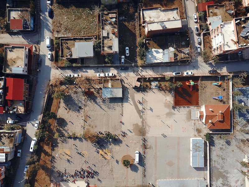
One of the applications of AI in GIS is georeferencing. Georeferencing is the process of associating images with coordinates in a local projection. With the help of AI, Bunting Labs can input PDFs, scanned pieces of paper, screenshots, or any other image, and the system can accurately identify features in the documents and match them to a digital map. Our CTO Brendan wrote more about the process behind georeferencing with AI, but here are some highlights: we built machine learning algorithms to “detect building edges, road outlines, the presence of sidewalks, and even parcel boundaries in the scanned drawing to align with the real world.” These algorithms are designed to be robust enough to handle drastic variations between maps, since PDF maps may be at different scales, may be missing features, or the features on the map such as road names may have changed.
This ability to quickly digitize geographical locations has numerous applications, such as utility coordination, construction planning, and asset management. For instance, a city’s civil engineer could use this technology to convert a filing cabinet of plan-sets containing their city’s water system into a web map.
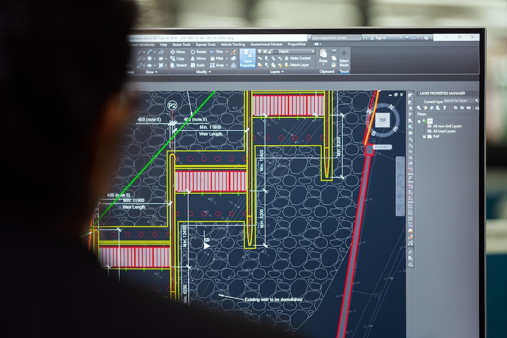
Vectorizing with AI
Vectorizing, or creating vector linework from a raster image, is another application of AI in GIS. Through AI, this process can be automated, improving accuracy and efficiency. Using AI algorithms, our software can identify distinct lines and convert them into vector lines to export as a GeoJSON, Shapefile, or DXF. This process significantly reduces the time and effort required to convert large amounts of raster data into vector format. What makes our solution unique among competitors is we consider the need for complete line extraction in GIS, and don’t settle for a vector representation that just looks similar to the raster from far away.
This ability to quickly extract features can help anyone who spends time digitizing maps. One example of this is creating utility maps, which normally requires sitting down at a computer to trace the lines of each subsurface utility, but with our software can be automated away with only QA/QC left for the user.
Use AI and ML within a GIS to Solve Custom Problems: ESRI
ESRI, one of the leaders in GIS, provides AI tools designed to cater to the user's unique needs. ESRI has been a key player in the GIS industry for decades, and they have been quick to adopt AI and ML into their platform.
Their AI tools are not just a single software but rather a suite of tools that are integrated with their ArcGIS platform. Instead of built-out solutions like you may see at Bunting Labs or FireScout, ESRI allows users to create their own GeoAI workflows. These are some highlights of their GeoAI capabilities:
Text Analysis
Text analysis involves extracting useful information from text data, which can then be used for further analysis or decision-making. With ESRI's AI tools, users can perform text analysis within the GIS environment. Natural language processing in a GIS has many possible use-cases, such as identifying written-out addresses, filling in metadata from text, and fixing misspelled addresses.
Pretrained Models
For those who are new to AI and ML, the concept of training a model can be daunting. It involves feeding the model with a large amount of data and allowing it to learn from that data. This process can be time-consuming and requires a high level of expertise.
To address this, ESRI provides a diverse selection of pretrained models that can be integrated right into your GIS without being an expert in AI. Pretrained models are models that have already been trained on a large amount of data, and they are ready to be used for various tasks. For example, there are models to detect ships from SAR, building footprints in China from high-resolution satellite imagery, or even arctic seals from drone imagery.
AutoDL
The most advanced, but least accessible, AI offering from ESRI is AutoDL. Deep learning is a subset of machine learning that is based on artificial neural networks. It is a powerful tool that has proven to be incredibly effective at tasks such as image recognition, natural language processing, and many more.
However, implementing a deep learning model can be complex and intimidating, especially for those who are not familiar with the field. To address this, ESRI provides AutoDL, a tool that automates much of the deep learning process. In theory, this allows GIS professionals to harness the power of deep learning without having to spend years becoming a machine learning engineer. The tool takes care of the heavy lifting, making AI easier to use, even for those with minimal coding skills.
That said, AutoDL may still benefit from or even, in some cases, require significant knowledge about data science to maximize its potential. The biggest blocker, though, is the need for a GPU. Many GPUs are extremely expensive, especially those used for deep learning. For reference, the GPUs we use to train our models retail for around $18,000. If deep learning isn’t a high priority, it may not be a cost-effective solution to buy a computer with a strong GPU for this.
Pairing GIS with AI and ML to Solve Problems: FireScout
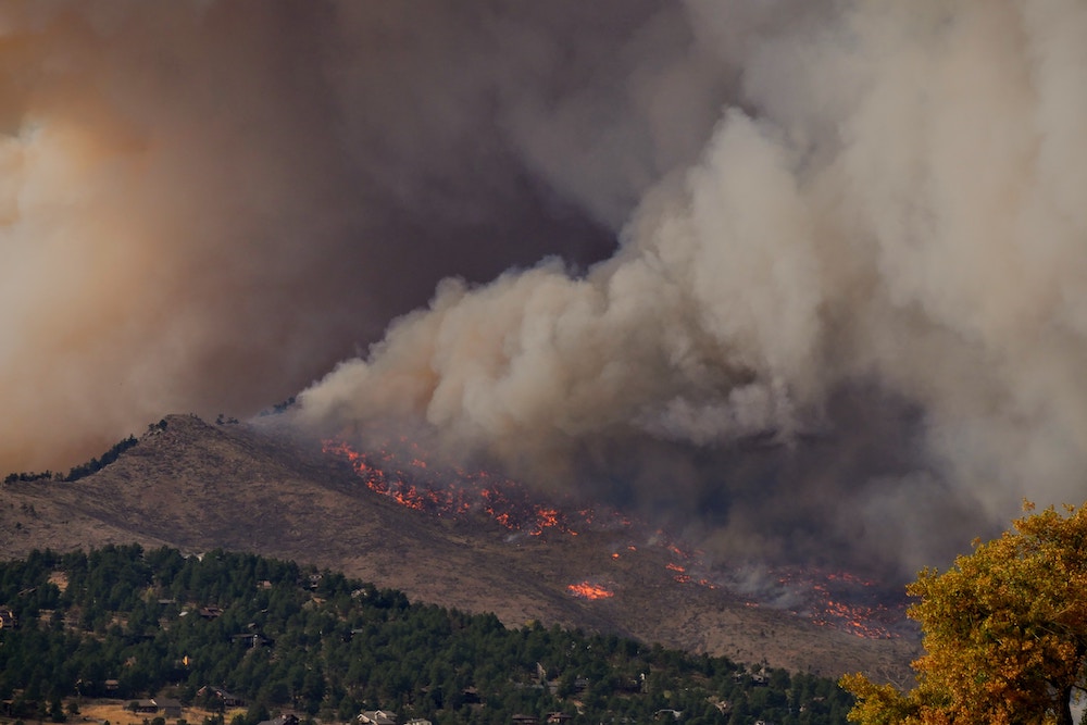
FireScout is a remarkable example of how GeoAI can be used to address real-world problems. FireScout utilizes computer vision to detect forest fires and then integrates it with its location, the direction of the fire, wind speed, wind direction, and temperature.
The system works by analyzing camera data and identifying fires from its model trained on “more than 10 million images.” Once a potential fire is detected, the system can alert authorities and provide them the geospatial data they need to fight the fire most quickly and efficiently. In a world where climate change is leading to an increase in the frequency and intensity of wildfires, a tool like FireScout is invaluable for protecting both human lives and the environment.
Using AI and ML to Create Spatial Data: Meta
Meta, known for its social media platform, is also a major player in the geospatial world. For example, Meta is a founder of the Overture Maps Foundation, has made significant additions to OpenStreetMap (notably, often through AI, as with their road tracing software), and has made acquisitions of geospatial companies, such as Mapillary, to develop their AR/VR capabilities.
What is especially interesting about Meta is their creation of complete datasets using GeoAI. A great example of this is their creation of population density maps. Broadly speaking, they have a three step approach: First, they work with the Center for International Earth Science Information Network to estimate population. Then, they use remote sensing and an algorithm they’ve developed to “scan the quantity and size of all buildings in each [30 meter] tile.” Finally, they estimate the tile’s population based on building density. This data has global coverage and was last updated in 2022.
Benefits of GeoAI
Increased Efficiency
One of the major benefits of GeoAI is increased efficiency. In traditional GIS, tasks like georeferencing and vectorizing were time-consuming and labor-intensive. However, with the integration of AI and ML, these tasks can now be automated, saving time and resources.
Improved User Experience
Another key benefit of GeoAI is the improved user experience for both GIS users and non-GIS professionals who interface with GIS. GeoAI can provide more accurate and detailed labeled data, provide a better understanding of global trends, and reduce the burden of manual work (whether it be tedious, as with vectorization, or lethal, as with trying to track down a fire).
Cost Savings
By increasing efficiency and improving the user experience, GeoAI can also lead to significant cost savings. Automated processes reduce the need for manual labor, resulting in lower operational costs. Furthermore, by freeing up highly-skilled GIS teams to work on projects outside of manual data creation, GIS teams can explore new ways to optimize their business.
Challenges of GeoAI
Data Quality
Data quality is another challenge in GeoAI. For AI and ML models to function effectively, they need high-quality, accurate data. Poor-quality or incomplete data can lead to inaccurate results and faulty predictions.
To address this, organizations need to implement data quality management practices. This includes validating the accuracy of the data, cleaning the data, and filling in any missing values. However, with improving data quality comes increased costs and time.
Complexity of Technology
The complexity of AI and ML technologies can also be a barrier to adoption, particularly for those without a technical background. While tools like ESRI's AutoDL have made it easier to use AI and ML, there is still a learning curve involved.
This means that, for the time being, many organizations are limited to working with premade solutions, such as those from Meta, FireScout, or Bunting Labs. Though it is possible to train and deploy your own models in house, it requires a significant dedication of time, talent, and money to accomplish.
Conclusion
We are just beginning to scratch the surface of what is possible with GeoAI. With advancements in AI and ML technology, advancements in hardware, and the increasing availability of spatial data, the future of GeoAI holds a lot of promise.
The applications of GeoAI are as diverse as they are powerful, from supply chain management to public health, and defense to humanitarian missions. Whether it's spotting wildfires long before humans, creating tools to track the supply chain in real time, or creating new spatial data from previously inaccessible sources, GeoAI has the potential to revolutionize how we understand and interact with our world.